Working with spatial and geometric operations in {sf}
Session 5
2023-09-27
1 Getting started
|
| | 0%
|
| | 1%
|
|= | 1%
|
|= | 2%
|
|== | 2%
|
|== | 3%
|
|=== | 4%
|
|=== | 5%
|
|==== | 5%
|
|==== | 6%
|
|===== | 7%
|
|===== | 8%
|
|====== | 8%
|
|====== | 9%
|
|======= | 9%
|
|======= | 10%
|
|======= | 11%
|
|======== | 11%
|
|======== | 12%
|
|========= | 12%
|
|========= | 13%
|
|========== | 14%
|
|========== | 15%
|
|=========== | 15%
|
|=========== | 16%
|
|============ | 16%
|
|============ | 17%
|
|============ | 18%
|
|============= | 18%
|
|============= | 19%
|
|============== | 19%
|
|============== | 20%
|
|============== | 21%
|
|=============== | 21%
|
|=============== | 22%
|
|================ | 22%
|
|================ | 23%
|
|================ | 24%
|
|================= | 24%
|
|================= | 25%
|
|================== | 25%
|
|================== | 26%
|
|=================== | 26%
|
|=================== | 27%
|
|=================== | 28%
|
|==================== | 28%
|
|==================== | 29%
|
|===================== | 29%
|
|===================== | 30%
|
|===================== | 31%
|
|====================== | 31%
|
|====================== | 32%
|
|======================= | 32%
|
|======================= | 33%
|
|======================= | 34%
|
|======================== | 34%
|
|======================== | 35%
|
|========================= | 35%
|
|========================= | 36%
|
|========================== | 37%
|
|========================== | 38%
|
|=========================== | 38%
|
|=========================== | 39%
|
|============================ | 39%
|
|============================ | 40%
|
|============================ | 41%
|
|============================= | 41%
|
|============================= | 42%
|
|============================== | 42%
|
|============================== | 43%
|
|=============================== | 44%
|
|=============================== | 45%
|
|================================ | 45%
|
|================================ | 46%
|
|================================= | 47%
|
|================================= | 48%
|
|================================== | 48%
|
|================================== | 49%
|
|=================================== | 49%
|
|=================================== | 50%
|
|=================================== | 51%
|
|==================================== | 51%
|
|==================================== | 52%
|
|===================================== | 52%
|
|===================================== | 53%
|
|====================================== | 54%
|
|====================================== | 55%
|
|======================================= | 55%
|
|======================================= | 56%
|
|======================================== | 56%
|
|======================================== | 57%
|
|======================================== | 58%
|
|========================================= | 58%
|
|========================================= | 59%
|
|========================================== | 59%
|
|========================================== | 60%
|
|========================================== | 61%
|
|=========================================== | 61%
|
|=========================================== | 62%
|
|============================================ | 62%
|
|============================================ | 63%
|
|============================================ | 64%
|
|============================================= | 64%
|
|============================================= | 65%
|
|============================================== | 65%
|
|============================================== | 66%
|
|=============================================== | 66%
|
|=============================================== | 67%
|
|=============================================== | 68%
|
|================================================ | 68%
|
|================================================ | 69%
|
|================================================= | 69%
|
|================================================= | 70%
|
|================================================= | 71%
|
|================================================== | 71%
|
|================================================== | 72%
|
|=================================================== | 72%
|
|=================================================== | 73%
|
|=================================================== | 74%
|
|==================================================== | 74%
|
|==================================================== | 75%
|
|===================================================== | 75%
|
|===================================================== | 76%
|
|====================================================== | 77%
|
|====================================================== | 78%
|
|======================================================= | 78%
|
|======================================================= | 79%
|
|======================================================== | 79%
|
|======================================================== | 80%
|
|======================================================== | 81%
|
|========================================================= | 81%
|
|========================================================= | 82%
|
|========================================================== | 82%
|
|========================================================== | 83%
|
|=========================================================== | 84%
|
|=========================================================== | 85%
|
|============================================================ | 85%
|
|============================================================ | 86%
|
|============================================================= | 87%
|
|============================================================= | 88%
|
|============================================================== | 88%
|
|============================================================== | 89%
|
|=============================================================== | 89%
|
|=============================================================== | 90%
|
|=============================================================== | 91%
|
|================================================================ | 91%
|
|================================================================ | 92%
|
|================================================================= | 92%
|
|================================================================= | 93%
|
|================================================================== | 94%
|
|================================================================== | 95%
|
|=================================================================== | 95%
|
|=================================================================== | 96%
|
|==================================================================== | 97%
|
|==================================================================== | 98%
|
|===================================================================== | 98%
|
|===================================================================== | 99%
|
|======================================================================| 99%
|
|======================================================================| 100%
|
| | 0%
|
| | 1%
|
|= | 1%
|
|= | 2%
|
|== | 2%
|
|== | 3%
|
|== | 4%
|
|=== | 4%
|
|=== | 5%
|
|==== | 5%
|
|==== | 6%
|
|===== | 6%
|
|===== | 7%
|
|===== | 8%
|
|====== | 8%
|
|====== | 9%
|
|======= | 9%
|
|======= | 10%
|
|======= | 11%
|
|======== | 11%
|
|======== | 12%
|
|========= | 12%
|
|========= | 13%
|
|========= | 14%
|
|========== | 14%
|
|========== | 15%
|
|=========== | 15%
|
|=========== | 16%
|
|============ | 16%
|
|============ | 17%
|
|============ | 18%
|
|============= | 18%
|
|============= | 19%
|
|============== | 19%
|
|============== | 20%
|
|============== | 21%
|
|=============== | 21%
|
|=============== | 22%
|
|================ | 22%
|
|================ | 23%
|
|================ | 24%
|
|================= | 24%
|
|================= | 25%
|
|================== | 25%
|
|================== | 26%
|
|=================== | 26%
|
|=================== | 27%
|
|=================== | 28%
|
|==================== | 28%
|
|==================== | 29%
|
|===================== | 29%
|
|===================== | 30%
|
|===================== | 31%
|
|====================== | 31%
|
|====================== | 32%
|
|======================= | 32%
|
|======================= | 33%
|
|======================= | 34%
|
|======================== | 34%
|
|======================== | 35%
|
|========================= | 35%
|
|========================= | 36%
|
|========================== | 36%
|
|========================== | 37%
|
|========================== | 38%
|
|=========================== | 38%
|
|=========================== | 39%
|
|============================ | 39%
|
|============================ | 40%
|
|============================ | 41%
|
|============================= | 41%
|
|============================= | 42%
|
|============================== | 42%
|
|============================== | 43%
|
|============================== | 44%
|
|=============================== | 44%
|
|=============================== | 45%
|
|================================ | 45%
|
|================================ | 46%
|
|================================= | 46%
|
|================================= | 47%
|
|================================= | 48%
|
|================================== | 48%
|
|================================== | 49%
|
|=================================== | 49%
|
|=================================== | 50%
|
|=================================== | 51%
|
|==================================== | 51%
|
|==================================== | 52%
|
|===================================== | 52%
|
|===================================== | 53%
|
|===================================== | 54%
|
|====================================== | 54%
|
|====================================== | 55%
|
|======================================= | 55%
|
|======================================= | 56%
|
|======================================== | 56%
|
|======================================== | 57%
|
|======================================== | 58%
|
|========================================= | 58%
|
|========================================= | 59%
|
|========================================== | 59%
|
|========================================== | 60%
|
|========================================== | 61%
|
|=========================================== | 61%
|
|=========================================== | 62%
|
|============================================ | 62%
|
|============================================ | 63%
|
|============================================ | 64%
|
|============================================= | 64%
|
|============================================= | 65%
|
|============================================== | 65%
|
|============================================== | 66%
|
|=============================================== | 66%
|
|=============================================== | 67%
|
|=============================================== | 68%
|
|================================================ | 68%
|
|================================================ | 69%
|
|================================================= | 69%
|
|================================================= | 70%
|
|================================================= | 71%
|
|================================================== | 71%
|
|================================================== | 72%
|
|=================================================== | 72%
|
|=================================================== | 73%
|
|=================================================== | 74%
|
|==================================================== | 74%
|
|==================================================== | 75%
|
|===================================================== | 75%
|
|===================================================== | 76%
|
|====================================================== | 76%
|
|====================================================== | 77%
|
|====================================================== | 78%
|
|======================================================= | 78%
|
|======================================================= | 79%
|
|======================================================== | 79%
|
|======================================================== | 80%
|
|======================================================== | 81%
|
|========================================================= | 81%
|
|========================================================= | 82%
|
|========================================================== | 82%
|
|========================================================== | 83%
|
|========================================================== | 84%
|
|=========================================================== | 84%
|
|=========================================================== | 85%
|
|============================================================ | 85%
|
|============================================================ | 86%
|
|============================================================= | 86%
|
|============================================================= | 87%
|
|============================================================= | 88%
|
|============================================================== | 88%
|
|============================================================== | 89%
|
|=============================================================== | 89%
|
|=============================================================== | 90%
|
|=============================================================== | 91%
|
|================================================================ | 91%
|
|================================================================ | 92%
|
|================================================================= | 92%
|
|================================================================= | 93%
|
|================================================================= | 94%
|
|================================================================== | 94%
|
|================================================================== | 95%
|
|=================================================================== | 95%
|
|=================================================================== | 96%
|
|==================================================================== | 96%
|
|==================================================================== | 97%
|
|==================================================================== | 98%
|
|===================================================================== | 98%
|
|===================================================================== | 99%
|
|======================================================================| 99%
|
|======================================================================| 100%2 Converting objects between types
Simple feature collection with 1 feature and 1 field
Geometry type: POINT
Dimension:     XY
Bounding box:  xmin: -76.71284 ymin: 39.25338 xmax: -76.71284 ymax: 39.25338
Geodetic CRS:  WGS 84
                name                   geometry
1 Example data frame POINT (-76.71284 39.25338)
3 Types of spatial operations
- Spatial filtering and topological relations
- Spatial joins and non-overlapping joins
- Spatial aggregation
Spatial filtering and topological relations
st_filter() defaults to intersecting geometries:
Simple feature collection with 6 features and 15 fields
Geometry type: MULTIPOLYGON
Dimension: XY
Bounding box: xmin: -83.67539 ymin: 36.54085 xmax: -74.68956 ymax: 42.51607
Geodetic CRS: NAD83
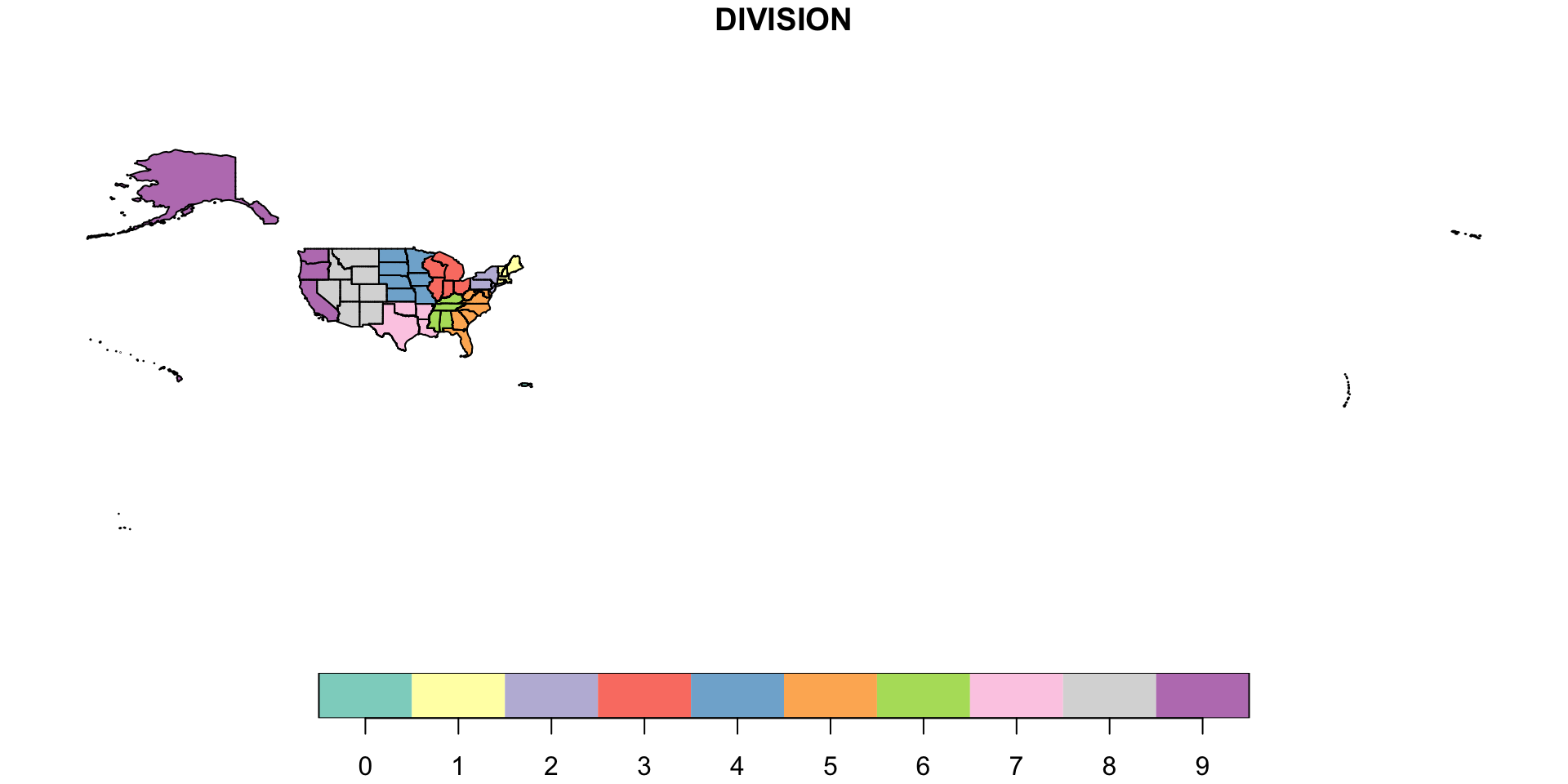
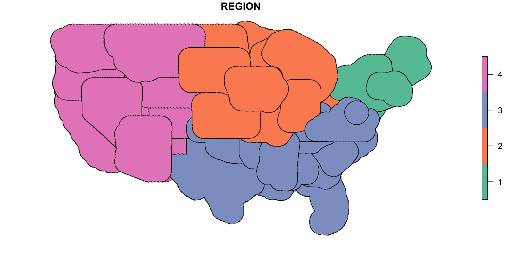
REGION DIVISION STATEFP STATENS GEOID GEOIDFQ STUSPS
1 3 5 54 01779805 54 0400000US54 WV
2 3 5 24 01714934 24 0400000US24 MD
3 3 5 10 01779781 10 0400000US10 DE
4 1 2 42 01779798 42 0400000US42 PA
5 3 5 51 01779803 51 0400000US51 VA
6 3 5 11 01702382 11 0400000US11 DC
NAME LSAD MTFCC FUNCSTAT ALAND AWATER INTPTLAT
1 West Virginia 00 G4000 A 62266513826 488918898 +38.6472854
2 Maryland 00 G4000 A 25151223822 6979843236 +38.9466584
3 Delaware 00 G4000 A 5046692239 1399219008 +38.9985661
4 Pennsylvania 00 G4000 A 115881476238 3397613881 +40.9046042
5 Virginia 00 G4000 A 102256342555 8529908321 +37.5222512
6 District of Columbia 00 G4000 A 158316181 18709785 +38.9042474
INTPTLON geometry
1 -080.6183274 MULTIPOLYGON (((-77.75438 3...
2 -076.6744939 MULTIPOLYGON (((-75.756 39....
3 -075.4416440 MULTIPOLYGON (((-75.50949 3...
4 -077.8275233 MULTIPOLYGON (((-75.5931 39...
5 -078.6681938 MULTIPOLYGON (((-76.9159 36...
6 -077.0165167 MULTIPOLYGON (((-77.11975 3...st_filter() can also support alternate topological relations:
Simple feature collection with 50 features and 15 fields
Geometry type: MULTIPOLYGON
Dimension:     XY
Bounding box:  xmin: -179.2311 ymin: -14.60181 xmax: 179.8597 ymax: 71.43979
Geodetic CRS:  NAD83
First 10 features:
   REGION DIVISION STATEFP  STATENS GEOID     GEOIDFQ STUSPS           NAME
1       3        5      12 00294478    12 0400000US12     FL        Florida
2       2        3      17 01779784    17 0400000US17     IL       Illinois
3       2        4      27 00662849    27 0400000US27     MN      Minnesota
4       1        1      44 01219835    44 0400000US44     RI   Rhode Island
5       4        8      16 01779783    16 0400000US16     ID          Idaho
6       1        1      33 01779794    33 0400000US33     NH  New Hampshire
7       3        5      37 01027616    37 0400000US37     NC North Carolina
8       1        1      50 01779802    50 0400000US50     VT        Vermont
9       1        1      09 01779780    09 0400000US09     CT    Connecticut
10      4        8      35 00897535    35 0400000US35     NM     New Mexico
   LSAD MTFCC FUNCSTAT        ALAND      AWATER    INTPTLAT     INTPTLON
1    00 G4000        A 138965379385 45968913048 +28.3989775 -082.5143005
2    00 G4000        A 143778206717  6216848695 +40.1028754 -089.1526108
3    00 G4000        A 206244791203 18937236061 +46.3159573 -094.1996043
4    00 G4000        A   2677768885  1323681453 +41.5964850 -071.5264901
5    00 G4000        A 214050504522  2390996667 +44.3484222 -114.5588538
6    00 G4000        A  23190211616  1025871482 +43.6727945 -071.5841886
7    00 G4000        A 125935965771 13453455061 +35.5397100 -079.1308636
8    00 G4000        A  23872594714  1030642813 +44.0589536 -072.6710173
9    00 G4000        A  12541999507  1816115183 +41.5798637 -072.7466572
10   00 G4000        A 314198519809   726531289 +34.4346843 -106.1316181
                         geometry
1  MULTIPOLYGON (((-83.10874 2...
2  MULTIPOLYGON (((-87.89243 3...
3  MULTIPOLYGON (((-95.31991 4...
4  MULTIPOLYGON (((-71.67881 4...
5  MULTIPOLYGON (((-116.3584 4...
6  MULTIPOLYGON (((-70.83887 4...
7  MULTIPOLYGON (((-77.89977 3...
8  MULTIPOLYGON (((-72.04187 4...
9  MULTIPOLYGON (((-72.5279 41...
10 MULTIPOLYGON (((-103.0647 3...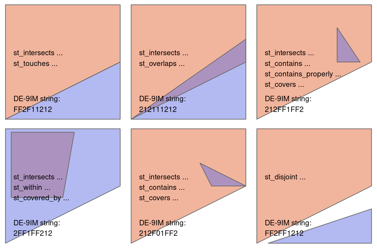
Spatial joins
Simple feature collection with 466 features and 19 fields
Geometry type: MULTIPOLYGON
Dimension: XY
Bounding box: xmin: -79.48765 ymin: 37.88661 xmax: -74.98628 ymax: 39.72304
Geodetic CRS: NAD83
First 10 features:
REGION DIVISION STATEFP STATENS GEOID GEOIDFQ STUSPS NAME LSAD
1 3 5 24 01714934 24 0400000US24 MD Maryland 00
1.1 3 5 24 01714934 24 0400000US24 MD Maryland 00
1.2 3 5 24 01714934 24 0400000US24 MD Maryland 00
1.3 3 5 24 01714934 24 0400000US24 MD Maryland 00
1.4 3 5 24 01714934 24 0400000US24 MD Maryland 00
1.5 3 5 24 01714934 24 0400000US24 MD Maryland 00
1.6 3 5 24 01714934 24 0400000US24 MD Maryland 00
1.7 3 5 24 01714934 24 0400000US24 MD Maryland 00
1.8 3 5 24 01714934 24 0400000US24 MD Maryland 00
1.9 3 5 24 01714934 24 0400000US24 MD Maryland 00
MTFCC.x FUNCSTAT ALAND AWATER INTPTLAT INTPTLON
1 G4000 A 25151223822 6979843236 +38.9466584 -076.6744939
1.1 G4000 A 25151223822 6979843236 +38.9466584 -076.6744939
1.2 G4000 A 25151223822 6979843236 +38.9466584 -076.6744939
1.3 G4000 A 25151223822 6979843236 +38.9466584 -076.6744939
1.4 G4000 A 25151223822 6979843236 +38.9466584 -076.6744939
1.5 G4000 A 25151223822 6979843236 +38.9466584 -076.6744939
1.6 G4000 A 25151223822 6979843236 +38.9466584 -076.6744939
1.7 G4000 A 25151223822 6979843236 +38.9466584 -076.6744939
1.8 G4000 A 25151223822 6979843236 +38.9466584 -076.6744939
1.9 G4000 A 25151223822 6979843236 +38.9466584 -076.6744939
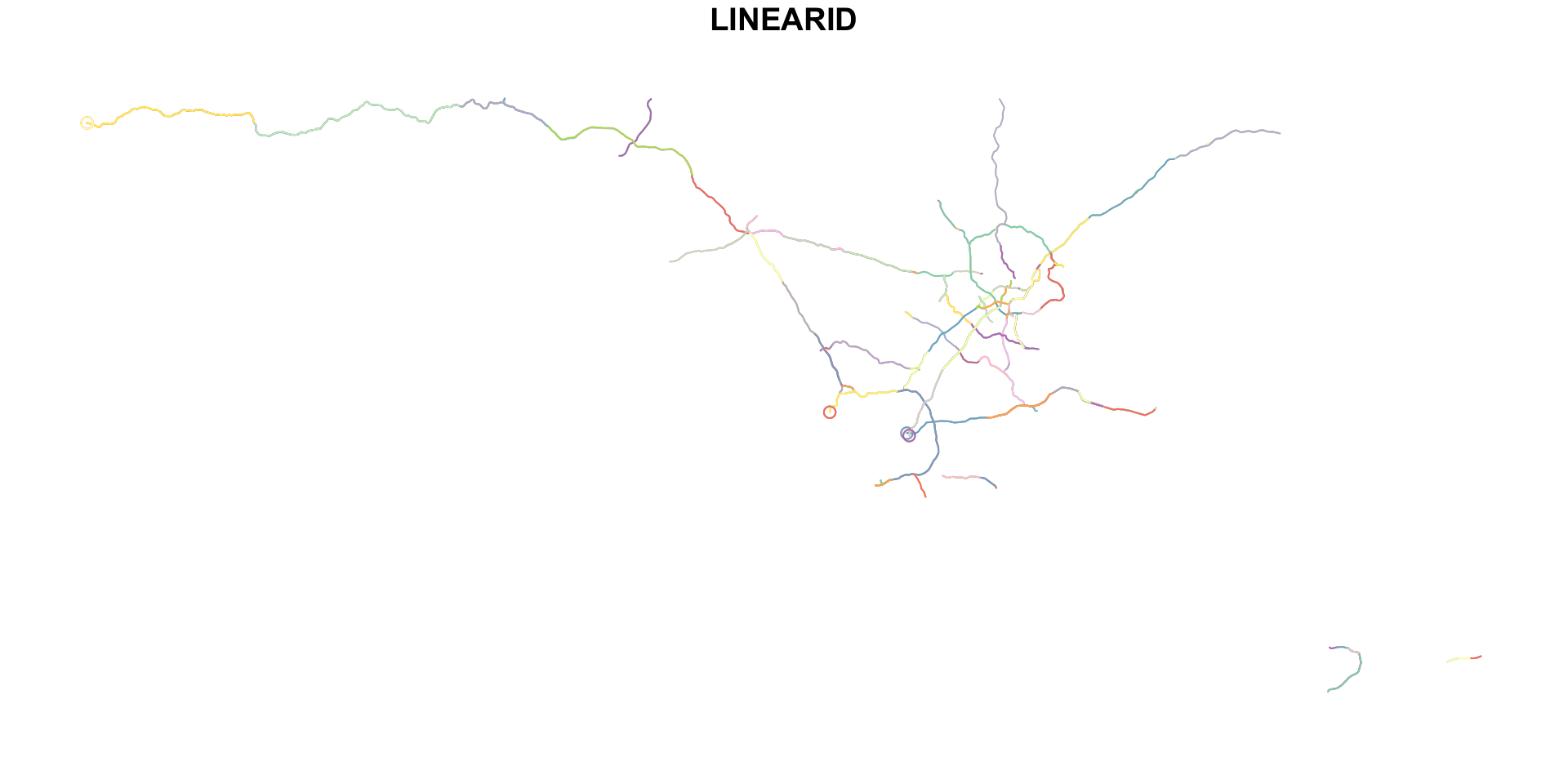
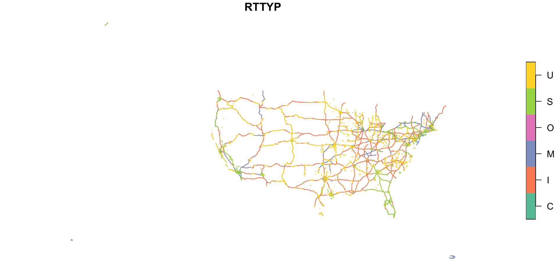
LINEARID FULLNAME RTTYP MTFCC.y geometry
1 1104258795090 Salisbury Byp M S1100 MULTIPOLYGON (((-75.756 39....
1.1 1103075320064 Salisbury Byp M S1100 MULTIPOLYGON (((-75.756 39....
1.2 1104258795072 Salisbury Byp M S1100 MULTIPOLYGON (((-75.756 39....
1.3 1104258845568 Salisbury Byp M S1100 MULTIPOLYGON (((-75.756 39....
1.4 110191599447 Salisbury Byp M S1100 MULTIPOLYGON (((-75.756 39....
1.5 110191599448 Salisbury Byp M S1100 MULTIPOLYGON (((-75.756 39....
1.6 1102149806067 Salisbury Byp M S1100 MULTIPOLYGON (((-75.756 39....
1.7 1102149813008 Salisbury Byp M S1100 MULTIPOLYGON (((-75.756 39....
1.8 1102149806121 Salisbury Byp M S1100 MULTIPOLYGON (((-75.756 39....
1.9 1102166635559 Salisbury Byp M S1100 MULTIPOLYGON (((-75.756 39....Non-overlapping joins
st_is_within_distance() is an example of a non-overlapping join:
Sparse geometry binary predicate list of length 17522, where the
predicate was `is_within_distance'
first 10 elements:
 1: (empty)
 2: (empty)
 3: (empty)
 4: (empty)
 5: (empty)
 6: (empty)
 7: (empty)
 8: (empty)
 9: (empty)
 10: (empty)
Filtering with spatial joins
You can use these joins for spatial filters using the base R syntax:
Simple feature collection with 2258 features and 4 fields
Geometry type: LINESTRING
Dimension:     XY
Bounding box:  xmin: -81.72573 ymin: 36.57507 xmax: -74.04969 ymax: 41.34626
Geodetic CRS:  NAD83
First 10 features:
          LINEARID      FULLNAME RTTYP MTFCC                       geometry
17  11013853809147 State Rte 611     S S1100 LINESTRING (-75.1366 40.350...
18  11013853809270 State Rte 611     S S1100 LINESTRING (-75.12634 40.28...
19  11013853809430 State Rte 611     S S1100 LINESTRING (-75.12603 40.28...
75  11013853864377  State Rte 29     S S1100 LINESTRING (-74.76432 40.20...
226  1105598256809  State Rte 26     S S1100 LINESTRING (-77.73622 40.89...
228  1108296536943  State Rte 26     S S1100 LINESTRING (-74.76814 40.20...
229  1108296536969  State Rte 26     S S1100 LINESTRING (-74.71174 40.27...
231  1104486135566  State Rte 26     S S1100 LINESTRING (-77.73356 40.89...
246  1108296538090 State Rte 129     S S1100 LINESTRING (-74.72239 40.18...
247  1108296538091 State Rte 129     S S1100 LINESTRING (-74.7224 40.183...
Filtering with spatial joins
Or using filter() if you use the name of the geomtery column (and convert the matrix output into a logical vector):
Simple feature collection with 2258 features and 4 fields
Geometry type: LINESTRING
Dimension:     XY
Bounding box:  xmin: -81.72573 ymin: 36.57507 xmax: -74.04969 ymax: 41.34626
Geodetic CRS:  NAD83
First 10 features:
         LINEARID      FULLNAME RTTYP MTFCC                       geometry
1  11013853809147 State Rte 611     S S1100 LINESTRING (-75.1366 40.350...
2  11013853809270 State Rte 611     S S1100 LINESTRING (-75.12634 40.28...
3  11013853809430 State Rte 611     S S1100 LINESTRING (-75.12603 40.28...
4  11013853864377  State Rte 29     S S1100 LINESTRING (-74.76432 40.20...
5   1105598256809  State Rte 26     S S1100 LINESTRING (-77.73622 40.89...
6   1108296536943  State Rte 26     S S1100 LINESTRING (-74.76814 40.20...
7   1108296536969  State Rte 26     S S1100 LINESTRING (-74.71174 40.27...
8   1104486135566  State Rte 26     S S1100 LINESTRING (-77.73356 40.89...
9   1108296538090 State Rte 129     S S1100 LINESTRING (-74.72239 40.18...
10  1108296538091 State Rte 129     S S1100 LINESTRING (-74.7224 40.183...
Spatial aggregation
4 Types of geometric operations
- Simplification
- Centroids
- Buffers
- Clipping (with or without subsetting)
- Unions
- Type transformations
Simplification
Simple feature collection with 49 features and 1 field (with 5 geometries empty)
Geometry type: GEOMETRY
Dimension: XY
Bounding box: xmin: -124.7989 ymin: 25.40562 xmax: -66.90256 ymax: 49.00013
Geodetic CRS: NAD83
First 10 features:
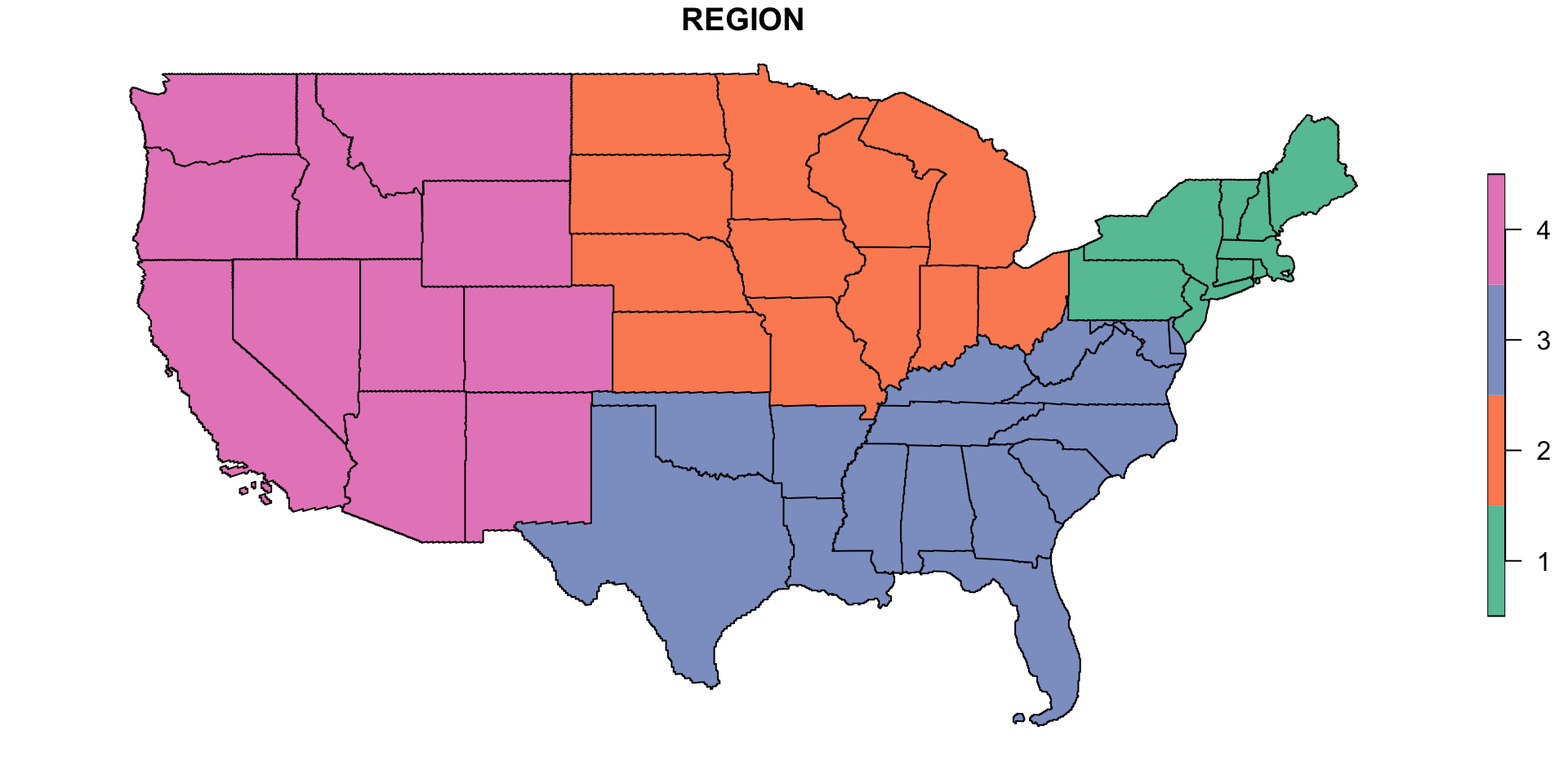
REGION geometry
1 3 POLYGON ((-78.36567 39.3604...
2 3 POLYGON ((-81.34136 25.4056...
3 2 POLYGON ((-89.45747 37.1908...
4 2 POLYGON ((-89.96571 47.2914...
5 3 POLYGON ((-75.78628 39.6205...
6 1 GEOMETRYCOLLECTION EMPTY
7 4 POLYGON ((-115.9605 47.8981...
8 1 POLYGON ((-70.9832 43.39448...
9 3 POLYGON ((-75.71132 36.2501...
10 1 POLYGON ((-71.58543 44.5129...
Centroids
Buffers
Clipping (with or without subsetting)
Unions

Type transformations
![]()