Reading and writing spatial data
Session 11
2026-04-15
Overview
- Spatial data is everywhere
- Navigating specifications, file formats, and services
- Working with common spatial file formats
- Working with popular spatial web services
Spatial data is everywhere
- Shapefiles, GeoJSON files, and other spatial data files
- Spatial data editing and hosting services, e.g. ArcGIS Online or Felt)
- Open data portals serving spatial and non-spatial data, e.g. data.gov
Spatial data is everywhere
- Google Maps, Apple Maps, Waze, and navigation apps (on your phone or in your vehicle)
- Biking and running apps (Strava publishes a global user activity heatmap)
- Web browsers on your phone and desktop application
Spatial data is everywhere
- Phone camera photos (stored in the EXIF metadata accessible via exiftoolr)
- Calendars (iCal), contacts (vCard), and emails (using IP address locations)
Creating spatial data is “easy”
- GIS Desktop applications, e.g. QGIS
- Web mapping applications (e.g. geojson.io, Felt)
- Spreadsheet applications (e.g. Google Sheets)
- Low-code data tools (e.g. Airtable or Microsoft Lists)
What can we do with it all?
- Read and write spatial data files
- Read and write related data files
- Read from and write to web services
Standards and specifications
Open Geospatial Consortium (OGC) Standards are organized into categories:
- APIs (e.g. Moving Features API)
- Web Services (e.g. Web Feature Service)
- Data Models and Encodings (e.g. GeoTIFF)
- and more (Sensors, Publish-Subscribe, Syndication & Context, Discovery, Containers, Abstract Specifications)
Standards and specifications

Source: xkcd: Standards (CC BY-NC 2.5)
Common spatial file formats
- Shapefile (
.shp) - GeoJSON (
.json,.geojson) - GeoPackage (
.gpkg) - KML - Keyhole Markup Language (
.kml) - Esri File Geodatabase (
.gdb) - GPX - GPS Exchange Format (
.gpx)
Common spatial file formats
These file formats vary in:
- How geometry is stored
- Input/output speed
- File size
- Compatibility with tools/systems
- Other constraints or limits
- And more!
Why are shapefiles bad?
Difficult to manage multiple files
Single geometry type per file
Attribute names can’t exceed 10 characters
Specialized spatial file formats
- Raster data
- Map tiles
Specialized spatial file formats
- Columnar data formats
- Row oriented
- Database services
- Local file databases
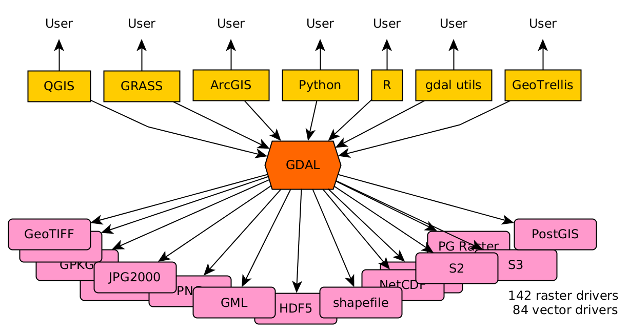
Historically, many tools and formats did not work together
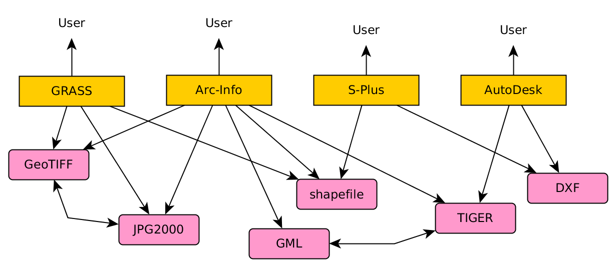
Now, GDAL supports translation between many different formats
Read spatial data files with R
The dsn or data source name for sf::read_sf() can include:
- a file name
- a URL
- a folder
- the name and access credentials of a database
- a character string with the contents of a GeoJSON file
Read spatial data files with R
You can use the query parameter of sf::read_sf() to use a SQL query to select records from a file (or select a specific geographical extent).
Many file formats can include spatial data
Non-spatial files can still be used to store Well Known Text (WKT) strings, coordinate values, or addresses (convertible to spatial data):
- Excel files (
xlsxorxls) - vCard or VCF (Virtual Contact File)
- EXIF metadata in a JPEG, HEIC, PNG, TIFF or other media file
Reading data into R
- Read data using
{sf} - Read data using a package that returns a
sfobject - Read data and use
{sf}to convert to asfobject
Writing data from R
- Write data to a spatial file using
{sf} - Write data a a non-spatial file using a different package
When you write spatial data to a non-spatial format, you should drop the geometry or convert the geometry to coordinates or well-known text.
Read data using {sf}
First load {sf}:
Read data using {sf}
{sf} can use any available drivers to read data:
name
PCIDSK PCIDSK
netCDF netCDF
PDS4 PDS4
VICAR VICAR
JP2OpenJPEG JP2OpenJPEG
PDF PDF
MBTiles MBTiles
BAG BAG
EEDA EEDA
OGCAPI OGCAPI
ESRI Shapefile ESRI Shapefile
MapInfo File MapInfo File
UK .NTF UK .NTF
LVBAG LVBAG
OGR_SDTS OGR_SDTS
S57 S57
DGN DGN
OGR_VRT OGR_VRT
Memory Memory
CSV CSV
GML GML
GPX GPX
KML KML
GeoJSON GeoJSON
GeoJSONSeq GeoJSONSeq
ESRIJSON ESRIJSON
TopoJSON TopoJSON
OGR_GMT OGR_GMT
GPKG GPKG
SQLite SQLite
ODBC ODBC
WAsP WAsP
PGeo PGeo
MSSQLSpatial MSSQLSpatial
PostgreSQL PostgreSQL
OpenFileGDB OpenFileGDB
DXF DXF
CAD CAD
FlatGeobuf FlatGeobuf
Geoconcept Geoconcept
GeoRSS GeoRSS
VFK VFK
PGDUMP PGDUMP
OSM OSM
GPSBabel GPSBabel
OGR_PDS OGR_PDS
WFS WFS
OAPIF OAPIF
EDIGEO EDIGEO
SVG SVG
Idrisi Idrisi
XLS XLS
ODS ODS
XLSX XLSX
Elasticsearch Elasticsearch
Carto Carto
AmigoCloud AmigoCloud
SXF SXF
Selafin Selafin
JML JML
PLSCENES PLSCENES
CSW CSW
VDV VDV
MVT MVT
NGW NGW
MapML MapML
GTFS GTFS
PMTiles PMTiles
JSONFG JSONFG
TIGER TIGER
AVCBin AVCBin
AVCE00 AVCE00
HTTP HTTP
long_name write copy
PCIDSK PCIDSK Database File TRUE FALSE
netCDF Network Common Data Format TRUE TRUE
PDS4 NASA Planetary Data System 4 TRUE TRUE
VICAR MIPL VICAR file TRUE TRUE
JP2OpenJPEG JPEG-2000 driver based on OpenJPEG library FALSE TRUE
PDF Geospatial PDF TRUE TRUE
MBTiles MBTiles TRUE TRUE
BAG Bathymetry Attributed Grid TRUE TRUE
EEDA Earth Engine Data API FALSE FALSE
OGCAPI OGCAPI FALSE FALSE
ESRI Shapefile ESRI Shapefile TRUE FALSE
MapInfo File MapInfo File TRUE FALSE
UK .NTF UK .NTF FALSE FALSE
LVBAG Kadaster LV BAG Extract 2.0 FALSE FALSE
OGR_SDTS SDTS FALSE FALSE
S57 IHO S-57 (ENC) TRUE FALSE
DGN Microstation DGN TRUE FALSE
OGR_VRT VRT - Virtual Datasource FALSE FALSE
Memory Memory TRUE FALSE
CSV Comma Separated Value (.csv) TRUE FALSE
GML Geography Markup Language (GML) TRUE FALSE
GPX GPX TRUE FALSE
KML Keyhole Markup Language (KML) TRUE FALSE
GeoJSON GeoJSON TRUE FALSE
GeoJSONSeq GeoJSON Sequence TRUE FALSE
ESRIJSON ESRIJSON FALSE FALSE
TopoJSON TopoJSON FALSE FALSE
OGR_GMT GMT ASCII Vectors (.gmt) TRUE FALSE
GPKG GeoPackage TRUE TRUE
SQLite SQLite / Spatialite TRUE FALSE
ODBC FALSE FALSE
WAsP WAsP .map format TRUE FALSE
PGeo ESRI Personal GeoDatabase FALSE FALSE
MSSQLSpatial Microsoft SQL Server Spatial Database TRUE FALSE
PostgreSQL PostgreSQL/PostGIS TRUE FALSE
OpenFileGDB ESRI FileGDB TRUE FALSE
DXF AutoCAD DXF TRUE FALSE
CAD AutoCAD Driver FALSE FALSE
FlatGeobuf FlatGeobuf TRUE FALSE
Geoconcept Geoconcept TRUE FALSE
GeoRSS GeoRSS TRUE FALSE
VFK Czech Cadastral Exchange Data Format FALSE FALSE
PGDUMP PostgreSQL SQL dump TRUE FALSE
OSM OpenStreetMap XML and PBF FALSE FALSE
GPSBabel GPSBabel TRUE FALSE
OGR_PDS Planetary Data Systems TABLE FALSE FALSE
WFS OGC WFS (Web Feature Service) FALSE FALSE
OAPIF OGC API - Features FALSE FALSE
EDIGEO French EDIGEO exchange format FALSE FALSE
SVG Scalable Vector Graphics FALSE FALSE
Idrisi Idrisi Vector (.vct) FALSE FALSE
XLS MS Excel format FALSE FALSE
ODS Open Document/ LibreOffice / OpenOffice Spreadsheet TRUE FALSE
XLSX MS Office Open XML spreadsheet TRUE FALSE
Elasticsearch Elastic Search TRUE FALSE
Carto Carto TRUE FALSE
AmigoCloud AmigoCloud TRUE FALSE
SXF Storage and eXchange Format FALSE FALSE
Selafin Selafin TRUE FALSE
JML OpenJUMP JML TRUE FALSE
PLSCENES Planet Labs Scenes API FALSE FALSE
CSW OGC CSW (Catalog Service for the Web) FALSE FALSE
VDV VDV-451/VDV-452/INTREST Data Format TRUE FALSE
MVT Mapbox Vector Tiles TRUE FALSE
NGW NextGIS Web TRUE TRUE
MapML MapML TRUE FALSE
GTFS General Transit Feed Specification FALSE FALSE
PMTiles ProtoMap Tiles TRUE FALSE
JSONFG OGC Features and Geometries JSON TRUE FALSE
TIGER U.S. Census TIGER/Line FALSE FALSE
AVCBin Arc/Info Binary Coverage FALSE FALSE
AVCE00 Arc/Info E00 (ASCII) Coverage FALSE FALSE
HTTP HTTP Fetching Wrapper FALSE FALSE
is_raster is_vector vsi
PCIDSK TRUE TRUE TRUE
netCDF TRUE TRUE FALSE
PDS4 TRUE TRUE TRUE
VICAR TRUE TRUE TRUE
JP2OpenJPEG TRUE TRUE TRUE
PDF TRUE TRUE FALSE
MBTiles TRUE TRUE TRUE
BAG TRUE TRUE TRUE
EEDA FALSE TRUE FALSE
OGCAPI TRUE TRUE TRUE
ESRI Shapefile FALSE TRUE TRUE
MapInfo File FALSE TRUE TRUE
UK .NTF FALSE TRUE TRUE
LVBAG FALSE TRUE TRUE
OGR_SDTS FALSE TRUE TRUE
S57 FALSE TRUE TRUE
DGN FALSE TRUE TRUE
OGR_VRT FALSE TRUE TRUE
Memory FALSE TRUE FALSE
CSV FALSE TRUE TRUE
GML FALSE TRUE TRUE
GPX FALSE TRUE TRUE
KML FALSE TRUE TRUE
GeoJSON FALSE TRUE TRUE
GeoJSONSeq FALSE TRUE TRUE
ESRIJSON FALSE TRUE TRUE
TopoJSON FALSE TRUE TRUE
OGR_GMT FALSE TRUE TRUE
GPKG TRUE TRUE TRUE
SQLite FALSE TRUE TRUE
ODBC FALSE TRUE FALSE
WAsP FALSE TRUE TRUE
PGeo FALSE TRUE FALSE
MSSQLSpatial FALSE TRUE FALSE
PostgreSQL FALSE TRUE FALSE
OpenFileGDB TRUE TRUE TRUE
DXF FALSE TRUE TRUE
CAD TRUE TRUE TRUE
FlatGeobuf FALSE TRUE TRUE
Geoconcept FALSE TRUE TRUE
GeoRSS FALSE TRUE TRUE
VFK FALSE TRUE FALSE
PGDUMP FALSE TRUE TRUE
OSM FALSE TRUE TRUE
GPSBabel FALSE TRUE FALSE
OGR_PDS FALSE TRUE TRUE
WFS FALSE TRUE TRUE
OAPIF FALSE TRUE FALSE
EDIGEO FALSE TRUE TRUE
SVG FALSE TRUE TRUE
Idrisi FALSE TRUE TRUE
XLS FALSE TRUE FALSE
ODS FALSE TRUE TRUE
XLSX FALSE TRUE TRUE
Elasticsearch FALSE TRUE FALSE
Carto FALSE TRUE FALSE
AmigoCloud FALSE TRUE FALSE
SXF FALSE TRUE TRUE
Selafin FALSE TRUE TRUE
JML FALSE TRUE TRUE
PLSCENES TRUE TRUE FALSE
CSW FALSE TRUE FALSE
VDV FALSE TRUE TRUE
MVT FALSE TRUE TRUE
NGW TRUE TRUE FALSE
MapML FALSE TRUE TRUE
GTFS FALSE TRUE TRUE
PMTiles FALSE TRUE TRUE
JSONFG FALSE TRUE TRUE
TIGER FALSE TRUE TRUE
AVCBin FALSE TRUE TRUE
AVCE00 FALSE TRUE TRUE
HTTP TRUE TRUE FALSERead data from a URL using {sf}
read_sf() works well with a direct link to a spatial data file.
Read a GeoJSON file:
Simple feature collection with 1 feature and 11 fields
Geometry type: MULTIPOLYGON
Dimension:     XY
Bounding box:  xmin: -124.4096 ymin: 32.53416 xmax: -114.1315 ymax: 42.00952
Geodetic CRS:  WGS 84
# A tibble: 1 × 12
  name       abbreviation capital    city   population   area waterarea landarea
  <chr>      <chr>        <chr>      <chr>       <int>  <int>     <int>    <int>
1 California CA           Sacramento Los A…   38332521 423968     20502   403466
# ℹ 4 more variables: houseseats <int>, statehood <date>, group <chr>,
#   geometry <MULTIPOLYGON [°]>
Read a KML file:
Simple feature collection with 161 features and 2 fields
Geometry type: POINT
Dimension:     XY
Bounding box:  xmin: -167.15 ymin: 0 xmax: 0 ymax: 69.3333
Geodetic CRS:  WGS 84
# A tibble: 161 × 3
   Name                                    Description             geometry
   <chr>                                   <chr>                <POINT [°]>
 1 "Patterson's bluegrass, Patterson blue… "<table wi… (-113.9553 43.39448)
 2 "Patterson's bluegrass, Patterson blue… "<table wi…  (-114.1191 46.0793)
 3 "Patterson's bluegrass, Patterson blue… "<table wi…  (-114.1191 46.0793)
 4 "Patterson's bluegrass, Patterson blue… "<table wi…  (-114.1191 46.0793)
 5 "Patterson's bluegrass, Patterson blue… "<table wi… (-109.5936 44.49239)
 6 "Patterson's bluegrass, Patterson blue… "<table wi…  (-114.1191 46.0793)
 7 "Patterson's bluegrass, Patterson blue… "<table wi…   (-109.817 40.7667)
 8 "Patterson's bluegrass, Patterson blue… "<table wi…            (-105 39)
 9 "Patterson's bluegrass, Patterson blue… "<table wi… (-106.1376 39.62102)
10 "Patterson's bluegrass, Patterson blue… "<table wi…   (-111.183 40.6167)
# ℹ 151 more rows
Read a GeoPackage file:
Simple feature collection with 100 features and 14 fields
Geometry type: MULTIPOLYGON
Dimension:     XY
Bounding box:  xmin: -84.32385 ymin: 33.88199 xmax: -75.45698 ymax: 36.58965
Geodetic CRS:  NAD27
# A tibble: 100 × 15
    AREA PERIMETER CNTY_ CNTY_ID NAME  FIPS  FIPSNO CRESS_ID BIR74 SID74 NWBIR74
   <dbl>     <dbl> <dbl>   <dbl> <chr> <chr>  <dbl>    <int> <dbl> <dbl>   <dbl>
 1 0.114      1.44  1825    1825 Ashe  37009  37009        5  1091     1      10
 2 0.061      1.23  1827    1827 Alle… 37005  37005        3   487     0      10
 3 0.143      1.63  1828    1828 Surry 37171  37171       86  3188     5     208
 4 0.07       2.97  1831    1831 Curr… 37053  37053       27   508     1     123
 5 0.153      2.21  1832    1832 Nort… 37131  37131       66  1421     9    1066
 6 0.097      1.67  1833    1833 Hert… 37091  37091       46  1452     7     954
 7 0.062      1.55  1834    1834 Camd… 37029  37029       15   286     0     115
 8 0.091      1.28  1835    1835 Gates 37073  37073       37   420     0     254
 9 0.118      1.42  1836    1836 Warr… 37185  37185       93   968     4     748
10 0.124      1.43  1837    1837 Stok… 37169  37169       85  1612     1     160
# ℹ 90 more rows
# ℹ 4 more variables: BIR79 <dbl>, SID79 <dbl>, NWBIR79 <dbl>,
#   geom <MULTIPOLYGON [°]>
Even non-spatial data works if the data includes a well-known text column:
Simple feature collection with 3 features and 4 fields
Geometry type: POINT
Dimension:     XY
Bounding box:  xmin: 0 ymin: 0 xmax: 44 ymax: 55
CRS:           NA
# A tibble: 3 × 5
  Id    Int64        Int32 WKT          geometry
  <chr> <chr>        <chr> <chr>         <POINT>
1 1     "0"          "33"  POINT(0 1)      (0 1)
2 2     "4294967297" "44"  POINT(44 55)  (44 55)
3 3     ""           ""    POINT(0 0)      (0 0)
If the non-spatial data does not include a well-known text column, read_sf() still returns a data frame:
# A tibble: 9,766 × 8
   Year  LEA   `LEA Name` School `School Name`         Grade    `Enrolled Count`
   <chr> <chr> <chr>      <chr>  <chr>                 <chr>    <chr>
 1 2023  01    Allegany   0301   Flintstone Elementary Prekind… 19
 2 2023  01    Allegany   0301   Flintstone Elementary Kinderg… 42
 3 2023  01    Allegany   0301   Flintstone Elementary Grade 1  33
 4 2023  01    Allegany   0301   Flintstone Elementary Grade 2  29
 5 2023  01    Allegany   0301   Flintstone Elementary Grade 3  26
 6 2023  01    Allegany   0301   Flintstone Elementary Grade 4  31
 7 2023  01    Allegany   0301   Flintstone Elementary Grade 5  36
 8 2023  01    Allegany   0301   Flintstone Elementary All Gra… 216
 9 2023  01    Allegany   0401   South Penn Elementary Prekind… 77
10 2023  01    Allegany   0401   South Penn Elementary Kinderg… 79
# ℹ 9,756 more rows
# ℹ 1 more variable: `Create Date` <chr>
A multifile format like a shapefile does not work as a URL:
Error:
! Cannot open "https://github.com/r-spatial/sf/raw/main/inst/shape/nc.shp"; The file doesn't seem to exist.
But it does work if you provide a local file path (system.file() returns a file path in this case):
Practice: Use a spatial query in wkt_filter
Simple feature collection with 4 features and 14 fields
Geometry type: POLYGON
Dimension:     XY
Bounding box:  xmin: -81.91116 ymin: 35.98933 xmax: -80.87086 ymax: 36.58965
Geodetic CRS:  NAD27
# A tibble: 4 × 15
   AREA PERIMETER CNTY_ CNTY_ID NAME   FIPS  FIPSNO CRESS_ID BIR74 SID74 NWBIR74
  <dbl>     <dbl> <dbl>   <dbl> <chr>  <chr>  <dbl>    <int> <dbl> <dbl>   <dbl>
1 0.114      1.44  1825    1825 Ashe   37009  37009        5  1091     1      10
2 0.061      1.23  1827    1827 Alleg… 37005  37005        3   487     0      10
3 0.199      1.98  1874    1874 Wilkes 37193  37193       97  3146     4     200
4 0.081      1.29  1880    1880 Watau… 37189  37189       95  1323     1      17
# ℹ 4 more variables: BIR79 <dbl>, SID79 <dbl>, NWBIR79 <dbl>,
#   geometry <POLYGON [°]>
Working with web services
Examples of common web services for working with spatial data include:
- Spatial data sharing and discovery
- Spatial data visualization
- Routing
- Geocoding
Considerations when working with web services
Using a web service often requires:
- Creating an account for authentication and billing
- Dedicating funding for usage
- Understanding data privacy implications
Example: ArcGIS Feature Services with read_sf
An ArcGIS FeatureServer URL does not work:
Error:
! Cannot open "https://services.arcgis.com/njFNhDsUCentVYJW/arcgis/rest/services/MDOT_SHA_County_Boundaries/FeatureServer/0"; The file doesn't seem to exist.
But a FeatureServer URL that includes the output format does work:
Simple feature collection with 24 features and 18 fields
Geometry type: POLYGON
Dimension:     XY
Bounding box:  xmin: -79.48731 ymin: 37.88654 xmax: -75.0492 ymax: 39.72288
Geodetic CRS:  WGS 84
# A tibble: 24 × 19
   OBJECTID COUNTY_NAME     COUNTY_INTEGER COUNTY_ABBREVIATION COUNTY_DIGITCAPS
      <int> <chr>                    <int> <chr>                          <int>
 1        1 Prince George's             16 PG                                16
 2        2 Cecil                        7 CE                                 7
 3        3 Howard                      13 HO                                13
 4        4 Talbot                      20 TA                                20
 5        5 Garrett                     11 GA                                11
 6        6 Baltimore City              24 BC                                24
 7        7 Carroll                      6 CL                                 6
 8        8 Washington                  21 WA                                21
 9        9 Worcester                   23 WO                                23
10       10 Frederick                   10 FR                                10
# ℹ 14 more rows
# ℹ 14 more variables: COUNTY_2DIGITCAPS <chr>, DISTRICT_NAME <chr>,
#   DISTRICT_NUMBER <int>, COUNTY_FIP <int>, COUNTYNUM <int>, TSD_ID <int>,
#   COUNTY <chr>, DISTRICT <int>, Shape__Area <dbl>, Shape__Length <dbl>,
#   COUNTY_ALLCAPS <chr>, Region <chr>, GlobalID <chr>, geometry <POLYGON [°]>
Example: ArcGIS Feature Services with arc_select
For ArcGIS Feature Services, the {arcgislayers} package is the recommended way to access data:
Simple feature collection with 24 features and 18 fields
Geometry type: POLYGON
Dimension:     XY
Bounding box:  xmin: 607669.3 ymin: 80997.33 xmax: 1870976 ymax: 757701.4
Projected CRS: NAD83(HARN) / Maryland (ftUS)
First 10 features:
   OBJECTID     COUNTY_NAME COUNTY_INTEGER COUNTY_ABBREVIATION COUNTY_DIGITCAPS
1         1 Prince George's             16                  PG               16
2         2           Cecil              7                  CE                7
3         3          Howard             13                  HO               13
4         4          Talbot             20                  TA               20
5         5         Garrett             11                  GA               11
6         6  Baltimore City             24                  BC               24
7         7         Carroll              6                  CL                6
8         8      Washington             21                  WA               21
9         9       Worcester             23                  WO               23
10       10       Frederick             10                  FR               10
   COUNTY_2DIGITCAPS DISTRICT_NAME DISTRICT_NUMBER COUNTY_FIP COUNTYNUM TSD_ID
1                 16    District 3               3         33        16      3
2                 07    District 2               2         15         7     21
3                 13    District 7               7         27        13     10
4                 20    District 2               2         41        20     18
5                 11    District 6               6         23        11      4
6                 24   No District               0        510        24     23
7                 06    District 7               7         13         6      1
8                 21    District 6               6         43        21   1060
9                 23    District 1               1         47        23      2
10                10    District 7               7         21        10     24
            COUNTY DISTRICT Shape__Area Shape__Length  COUNTY_ALLCAPS Region
1  Prince George's        3 13902243040      720691.0 PRINCE GEORGE'S   <NA>
2            Cecil        2 11643675836      494670.7           CECIL   <NA>
3           Howard        7  7056288549      471922.1          HOWARD   <NA>
4           Talbot        2 13193323636      657963.0          TALBOT   <NA>
5          Garrett        6 18339518744      680782.9         GARRETT   <NA>
6   Baltimore City        0  2562810672      207145.0  BALTIMORE CITY   <NA>
7          Carroll        7 12623420879      651107.6         CARROLL   <NA>
8       Washington        6 13031238277      948164.4      WASHINGTON   <NA>
9        Worcester        1 16297527948      694972.5       WORCESTER   <NA>
10       Frederick        7 18613257293      683407.8       FREDERICK   <NA>
                               GlobalID                       geometry
1  8dec0b24-8a66-47c5-97ec-aa0ef22dc80a POLYGON ((1313442 476110.4,...
2  4ea4cc1d-607c-41cd-b35c-6eae0d049b50 POLYGON ((1660741 628728.5,...
3  0241b589-d266-4eb6-8403-a0d5a6660b7d POLYGON ((1391417 567919.8,...
4  f14b3860-0b31-41d6-a0f9-8f16468e10d4 POLYGON ((1611348 457521.9,...
5  247e3d29-1b5c-423b-a793-5c694d42cf34 POLYGON ((769889 754580.7, ...
6  89c9198d-40cb-4f46-8b08-6b62b0b29885 POLYGON ((1445534 565803.6,...
7  c8aa72df-586c-4ba2-97de-b86a6e486b0d POLYGON ((1371781 748182.4,...
8  eea627a4-f12d-453a-a9dc-8dbb3fcdf826 POLYGON ((936016.4 751530.6...
9  70d147e2-cc68-470b-bc8c-41bdcea19451 POLYGON ((1870321 284172.9,...
10 ae254bf4-2ea3-4c79-ae24-a83a993c7b20 POLYGON ((1213130 747989.9,...
Example: ArcGIS Portal Items with arc_open
{arcgislayers} also has support for getting data on “portal items” like web maps and applications:
Practice: Write a SQL expression to query a FeatureLayer
Use the format “{Field_name} {Operator} {Value or String}” to build a query and filter data before loading it to your computer.
Check out the SQL reference for ArcGIS query expressions for more information.
Simple feature collection with 10 features and 23 fields
Geometry type: POINT
Dimension:     XY
Bounding box:  xmin: -76.68608 ymin: 39.30426 xmax: -76.63588 ymax: 39.34304
Geodetic CRS:  WGS 84
      RowID         SRRecordID ServiceRequestNum
1  10054845 5004w00002sWMk0AAG       24-00000007
2  10054846 5004w00002sWMkQAAW       24-00000008
3  10054850 5004w00002sWMpeAAG       24-00000001
4  10054852 5004w00002sWMxJAAW       24-00000021
5  10054864 5004w00002sWN2cAAG       24-00000005
6  10054865 5004w00002sWN2mAAG       24-00000006
7  10054866 5004w00002sWN2NAAW       24-00000002
8  10054867 5004w00002sWN2rAAG       24-00000009
9  10054869 5004w00002sWN2wAAG       24-00000011
10 10054872 5004w00002sWN3BAAW       24-00000013
                                  SRType MethodReceived         CreatedDate
1  TRS-48 Hour Parking/Abandoned Vehicle            API 2023-12-31 19:11:10
2                    SW-Graffiti Removal            API 2023-12-31 19:12:21
3                ECC-Information Request          Phone 2023-12-31 19:01:11
4                ECC-Information Request          Phone 2023-12-31 19:30:43
5                ECC-Information Request          Phone 2023-12-31 19:08:13
6                        SW-Dirty Street            API 2023-12-31 19:08:56
7                ECC-Information Request          Phone 2023-12-31 19:03:46
8                ECC-Information Request          Phone 2023-12-31 19:12:23
9                ECC-Information Request          Phone 2023-12-31 19:15:51
10               ECC-Information Request          Phone 2023-12-31 19:19:49
   SRStatus          StatusDate             DueDate           CloseDate
1    Closed 2024-01-05 10:58:07 2024-01-07 19:11:09 2024-01-05 10:58:07
2    Closed 2024-01-03 09:45:00 2024-01-14 19:12:21 2024-01-03 09:45:00
3    Closed 2023-12-31 19:02:00 2023-12-31 14:01:11 2023-12-31 19:02:00
4    Closed 2023-12-31 19:31:30 2023-12-31 14:30:43 2023-12-31 19:31:30
5    Closed 2023-12-31 19:09:08 2023-12-31 14:08:13 2023-12-31 19:09:08
6    Closed 2024-01-03 09:31:00 2024-01-09 19:08:56 2024-01-03 09:31:00
7    Closed 2023-12-31 19:04:01 2023-12-31 14:03:46 2023-12-31 19:04:00
8    Closed 2023-12-31 19:13:03 2023-12-31 14:12:23 2023-12-31 19:13:03
9    Closed 2023-12-31 19:16:05 2023-12-31 14:15:51 2023-12-31 19:16:05
10   Closed 2023-12-31 19:20:04 2023-12-31 14:19:49 2023-12-31 19:20:04
                                               Agency     LastActivity
1  Transportation                                     Service Response
2  Solid Waste                                        Service Response
3  ECC                                                            <NA>
4  ECC                                                            <NA>
5  ECC                                                            <NA>
6  Solid Waste                                        Service Response
7  ECC                                                            <NA>
8  ECC                                                            <NA>
9  ECC                                                            <NA>
10 ECC                                                            <NA>
      LastActivityDate                                             Outcome
1  2024-01-05 10:58:07 SR closed by agency-specific work management system
2  2024-01-03 09:45:00                         Work could not be completed
3                 <NA>                                                <NA>
4                 <NA>                                                <NA>
5                 <NA>                                                <NA>
6  2024-01-03 09:31:00      SR assessed and no cause for action determined
7                 <NA>                                                <NA>
8                 <NA>                                                <NA>
9                 <NA>                                                <NA>
10                <NA>                                                <NA>
                                        Address ZipCode Neighborhood
1      5242 FAIRLAWN AVE, Baltimore City, 21215   21215     Woodmere
2      1909 N FULTON AVE, Baltimore City, 21217   21217   Penn North
3                                          <NA>    <NA>         <NA>
4                                          <NA>    <NA>         <NA>
5                                          <NA>    <NA>         <NA>
6  1800 PENNSYLVANIA AVE, Baltimore City, 21217   21217        Upton
7                                          <NA>    <NA>         <NA>
8                                          <NA>    <NA>         <NA>
9                                          <NA>    <NA>         <NA>
10                                         <NA>    <NA>         <NA>
   CouncilDistrict PoliceDistrict PolicePost           Latitude
1                6   Northwestern        633 39.343041765917619
2                7        Western        731 39.310466431895868
3             <NA>           <NA>       <NA>               <NA>
4             <NA>           <NA>       <NA>               <NA>
5             <NA>           <NA>       <NA>               <NA>
6               11        Western        713 39.304256585322513
7             <NA>           <NA>       <NA>               <NA>
8             <NA>           <NA>       <NA>               <NA>
9             <NA>           <NA>       <NA>               <NA>
10            <NA>           <NA>       <NA>               <NA>
             Longitude                               GeoLocation
1  -76.686078294484034 (39.343041765917619, -76.686078294484034)
2  -76.646214120936790 (39.310466431895868, -76.646214120936790)
3                 <NA>                                      <NA>
4                 <NA>                                      <NA>
5                 <NA>                                      <NA>
6  -76.635878307194716 (39.304256585322513, -76.635878307194716)
7                 <NA>                                      <NA>
8                 <NA>                                      <NA>
9                 <NA>                                      <NA>
10                <NA>                                      <NA>
                     geometry
1  POINT (-76.68608 39.34304)
2  POINT (-76.64621 39.31047)
3                 POINT EMPTY
4                 POINT EMPTY
5                 POINT EMPTY
6  POINT (-76.63588 39.30426)
7                 POINT EMPTY
8                 POINT EMPTY
9                 POINT EMPTY
10                POINT EMPTY
Example: Mapbox API
mapboxapi::mb_isochrone() allows access to the Mapbox Isochrone API:
Example: Mapbox API
mapboxapi::addMapboxTiles() provides easy access to the Mapbox Static Tiles API:
Error in `addMapboxTiles()`:
! could not find function "addMapboxTiles"
mapgl::mapboxgl() is now a recommended alternative to addMapboxTiles().
Storing and organizing spatial data takes planning
Planning for the structure and organization of your data can be supported using a variety of tools:
![]()